Map of Italy
Updated · BootsnAll
Italy had the good sense to shape itself like a boot, which makes it easy to find on any map or globe. The hard part is the 20 regions inside it.
I think of them by where they sit on the leg: Rome is roughly at the knee, Naples at the shin, Puglia is the heel and Calabria the toe, with Sicily the ball being kicked. It means picturing Italy as a thigh-high stiletto rather than an ankle boot, which suits the country anyway.
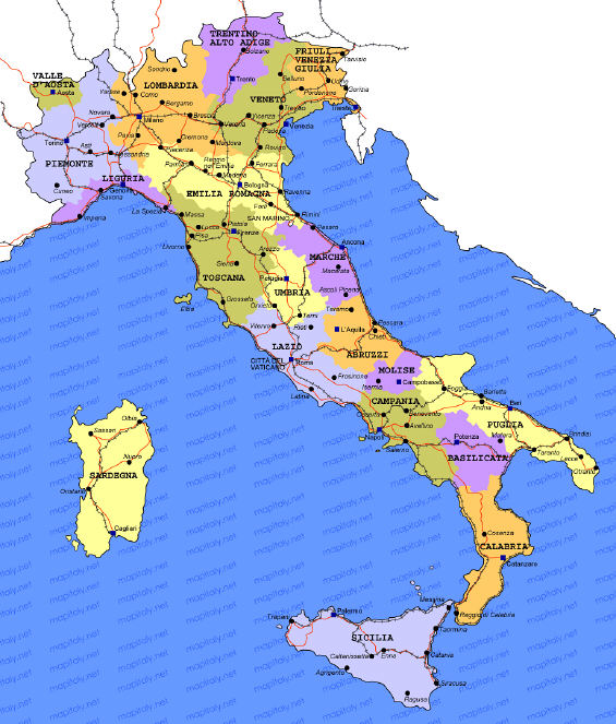
Map of Italy with Cities
Here is a map of Italy’s regions with some of the major cities in each region marked:
If you want to zoom in, this interactive map lets you pan from the Alps to Sicily:
Italy’s 20 Regions and Their Capitals
Five regions (Sicily, Sardinia, Aosta Valley, Trentino-Alto Adige and Friuli-Venezia Giulia) have a special statute that gives them extra self-government, which is why you’ll see bilingual signs in Aosta and Alto Adige. The regional capital is often, but not always, the city you’d want to visit.
| Region | Capital | Where on the boot |
|---|---|---|
| Aosta Valley | Aosta | Top left, on the French and Swiss borders |
| Piedmont | Turin | Northwest |
| Liguria | Genoa | The northwest coast (the Italian Riviera) |
| Lombardy | Milan | North, with the big lakes |
| Trentino-Alto Adige | Trento | North, in the Dolomites |
| Veneto | Venice | Northeast |
| Friuli-Venezia Giulia | Trieste | Far northeast, on the Slovenian border |
| Emilia-Romagna | Bologna | Across the top of the leg |
| Tuscany | Florence | The thigh, west side |
| Umbria | Perugia | The thigh, inland |
| Marche | Ancona | The thigh, Adriatic side |
| Lazio | Rome | The knee, west side |
| Abruzzo | L’Aquila | The knee, Adriatic side |
| Molise | Campobasso | Below the knee, Adriatic side |
| Campania | Naples | The shin, west side |
| Puglia (Apulia) | Bari | The heel |
| Basilicata | Potenza | The instep |
| Calabria | Catanzaro | The toe |
| Sicily | Palermo | The ball at the toe |
| Sardinia | Cagliari | The island well off the west coast |
Two small independent countries sit inside Italy as well: Vatican City, in Rome, and the Republic of San Marino, on the border of Emilia-Romagna and Marche. Neither has border checks.
Which Map You Actually Need
A map like the one above is for getting your bearings, not for getting around. What you need depends on how you travel.
If you’re taking trains: you barely need a map of the country at all. The Trenitalia and Italo apps show every stop, and a phone map app gets you from the station to your hotel. Download the offline area for each city in Google Maps before you go, so you’re covered when your data runs out or the signal drops in a medieval alley.
If you’re driving in Italy: use a navigation app, but carry a paper road map too. A folding map shows you the shape of a whole day’s drive in a way a phone screen can’t, and it works in the valleys where the signal disappears. The Michelin Italy road map is the standard; for more detail, get a spiral-bound road atlas such as the Touring Club Italiano atlas, or a regional Michelin sheet for the area you’re exploring. Regional maps are also sold at newsstands and bookshops in the bigger tourist towns.
One warning for drivers: navigation apps will happily route you into a ZTL, the camera-enforced limited traffic zones that cover most historic centers. Each unauthorized entry is a fine of 83 to 332 euros in 2026, plus your rental company’s admin fee, and a few wrong turns can mean several fines. Park outside the old town and walk in.
If you’re exploring cities on foot: a phone map does the job almost everywhere except Venice, where GPS struggles among the narrow calli and the blue dot drifts. A paper map from your hotel plus the yellow “Per Rialto” and “Per San Marco” signs painted on the walls will get you there. The city maps I liked best are still handy for spotting sights you’d miss on a small screen, and for Venice, these Venice mapping websites help you find a specific address.